


Trve Northern New England Black Metal
Lochwood Tower
The first of the Johnstone’s of Annandale was one John, to whom Robert de Brus, Lord of Annandale, granted a tract of land on the west side of Upper Annandale (c1170-90) and there established a toun (“settlement” in Middle English; tun in Old English). The surname literally translates to “John’s town”.
Known at first as Johnston, and later as Lochwood, this castle was rebuilt and extended several times until it became one of the most important strongholds in the Scottish West March.
Lochwood began, like so many castles and strongholds of the day, as a timber motte and baily stronghold. The remaining evidence of this is the partially artificial mount (motte) to the north of the present-day ruins. A motte-and-bailey castle was made up of two structures: a motte (a type of mound – often artificial – topped with a wooden or stone structure known as a keep); and at least one bailey (a fortified enclosure built next to the motte). Nothing remains of the keep or bailey supporting the assumption of timber construction.
It was most likely during the 14th century that the old motte and bailey was succeeded by a new castle built of stone. The family had attained a leading position in Border affairs before 1380 and would by then have required something more substantial for their protection than a simple timber motte and bailey. The new castle is presumed to have been built on the site of the original bailey, immediately south of the motte where the present northern extents of the ruins stand.
The first time we know that the tower was referenced by name took place in November 1476, when John Johnstone signed a document transferring the ownership of the lands of Wamphray to his son. He signed the deed as being from ‘Lochwod.’ From here on out, the castle began to appear frequently, and was often mentioned in connection to border disputes, but it wasn’t until the wars with England that Lochwood came into prominence as a stronghold of national importance, when, in 1547, the English captured Lochwood, since Lord Johnstone was a prisoner in England and the castle only lightly guarded, and chose it as their base in Upper Annandale.
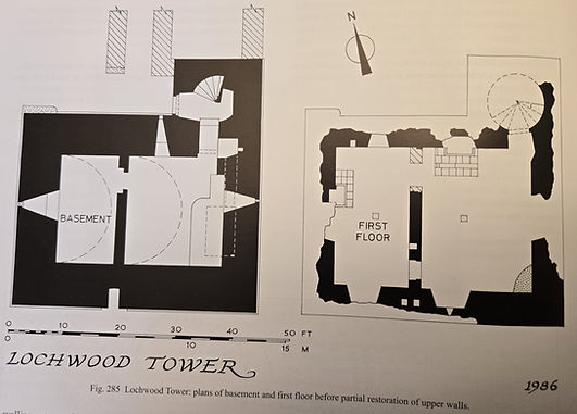
The ruins of Lochwood lie to the east of a promontory about 2,000 feet long and 1,300 feet wide, which thrusts northwards into an area of largely-unreclaimed moss. The tower, which was once a strong castle, incorporates some 15th-century work. Not much remains above the level of the vaulted basement. There was a courtyard contained by a wall, which contained the kitchen and other buildings. The entrance, which led to a wide turnpike stair, was in the wing. On the north was a hillock 'apparently in part artificial' named 'The Mount', a circular double-terraced motte with ramparts, apparently a Norman predecessor of the stone tower. To the south of the tower, in the center of a level meadow which was probably the garden, was an artificially-looking, ditched earthen mound, some 9 feet (2.7 m) high and 36 feet (11 m) to 40 feet (12 m) across the base.
It is said that King James V (1513-1542), on riding up to Lochwood, cried out ‘he who built it must have been a knave in his heart!’ suggesting that there were likely several impressive defensive elements to the site and the castle being of grand scale.
The English captured the tower in 1547, during the Rough Wooing, and held it until 1550. The castle was described by Sir Thomas Carlton at its capture as 'a fair large tower, able to lodge all our company safely, with a barmkin, hall, kitchen and stables, all within the barmkin…'.
Edward Seymour, 1st Duke of Somerset, the English commander, wrote of the capture of Lochwood:
“We came there about half an hour before daybreak and the greater part of us lay close without the barmekin but about a dozen of the men got over the barmekin wall and stole close into the house within the barmekin (enclosure wall) and took the wenches there and kept them secure in the house till daylight. At sunrise, two men and a woman, being in the tower, one of the men rising in his shirt and going to the tower head and seeing nothing stir about he called to the wench that lay in the tower and bade her rise and open the tower door and call up them that lay beneath. She so doing and opening the iron door and a wood door without it, our men within the barmekin brake a little too soon to the door and the wench perceiving them, leaped back into the tower and had almost got the wood door shut but one of our men got hold it that she could not get it closed. So the skirmish arose and we scaled the barmekin and broke open the wood door and she being troubled with the wood door left the iron door open and so we entered and won the Loghwood; where we found truly the house well purveyed with salted beef, malt, barley, oatmeal, butter and cheese.”
Luckily, the Johnstone’s reclaimed their home in 1550, and continued to live at the castle until the late 1600s. By this point, Lochwood had become outmoded, and its owner, the Earl of Annandale, spent most of his time in Edinburgh instead of at the old clan seat.
It was while the Johnstone-Maxwell feud was at its height, in 1585, that the Maxwells, led by Robert Maxwell of Cowhill along with a contingent of Armstrongs and about 120 English and Scots rebels attacked and burnt Lochwood and ‘brint the place, mantioun, and haill houses thairoff. With the haill insycht thairin, bedding, plenesching, and brint and distroyit my chartour kist with my haill evedentis and wreittis besyd uther jowellis.” The loss of the family charters was a huge blow to both family and history at large, but no time would have been wasted in repairing the castle. It was rebuilt, and James VI of Scotland and Ludovic Stewart, 2nd Duke of Lennox stayed on 11 October 1592. James the VI stayed there again in 1602 on one of his expeditions to quieten the borders. The castle was abandoned around 1773 and since has fallen into the ruin before you now.
The Castle
The major part of the ruins dates to the 15th century being the remains of the stronghold depicted on the ‘Platte of Castlemilk’, a pictorial map that included thumbnail sketches of all the principal strongholds, including Lochwood. The northern enclosure is the earlier of the stone iterations of Lochwood, and may represent a much-altered vestige of the first stone castle. It measures, on average, 81 feet from north to south and 95 feet from east to west. Along the north wall are the remains of a building range with walls 4 foot 6 inch thick and an internal width of 13 feet. A section of walling entrapped by tree roots suggests it was at least two stories’ high. Another range, which was excavated in 1982, extended the whole length of the east wall. It comprised three chambers, each with an internal width of 15 feet and inner walls averaging 3 feet in thickness, which were reached from a common passage along the west side. The most northerly chamber was a kitchen or bakehouse with a relatively small fireplace, 4 foot 10 inch wide, in the north wall. Immediately outside at this point (and outside the barmkin) is a large, circular oven, some 5 foot 4 inch in diameter. The remains of another, larger oven, 7 foot 2 inch in diameter, were found at ground level in the northwest corner of this building, but without any obvious means of access, suggesting it had been abandoned and closed off. The remains of a third range of buildings on the west side of the courtyard were partially excavated in 1968. This revealed a room measuring 24 foot by 13 foot internally, with a fireplace at the south end, a central doorway and inner walls 2 foot 9 inch thick which was a 17th century addition. The continuation of this enclosure’s outer wall right across the south side (apart from a gateway, now gone) effectively segregated the town courtyards.
The south courtyard was much more open, the only known buildings being the large east range, 60 foot 6 inch long and 29 feet 6 inch wide, inserted between the tower and the earlier, northern, courtyard. At basement level this range comprised a fine kitchen and two vaulted cellars connected on the west side by a common service passage while to the north of the passage, and entered directly from the kitchen, there was another smaller chamber, probably a store room, with an aumbry. The kitchen was at the north end of this range, with its great fireplace, 14 foot 3 inch wide and 4 foot 6 inch deep, separated from the rest if the room by a fine semi-circular arch, some 8 foot 6 inch wide, with finely wrought, ashlar voussoirs and rounded arises. Only the west end of this arch survives. The other feature in the kitchen is a slop sink, which discharged outside the barmkin on the east side. The masonry of this range is local rubble with sandstone dressings, and the walls are 3 foot 6 inch thick. In all probability this range was the barnekin-hall’ mentioned by Carlton, the first floor of which would have been the great hall of the castle.
The tower itself appears to date from the late 15th century. The thickness of the wall, 7 foot 8 inch at basement level and 5 foot 6 inch at the first floor, and the lack of any provision for firearms virtually precludes a later date while the use of older, probably 14th century moldings, possibly from the earlier tower that more than likely existed in the northern barmkin, solidifies the assumption of the date range for construction. The tower is built on the L-plan, and has a main block measuring 43 foot 8 inch by 34 foot 6 inch, from the north end to the stair wing, 17 feet 6 inch wide which projects 10 feet 5 inches to the north. There is a splayed plinth course. The masonry is local rubble with red sandstone moldings. Apart from the QER moldings around the entrance, all the margins have rounded or chamfered arises.
The entrance, which is at ground level in the re-entrant angle, was protected by the usual wooden door and iron yett. The admitted directly to the unusually large wheel-stair, 10 feet in diameter, and a mural passage leading to the basement. A low doorway, only 3 feet 6 inch high, on the east side of this passage leads down to a second mural passage serving the prison. The latter passage, which is only 5 feet high, is roofed throughout its length with large dressed, sandstone slabs, all of which have come from earlier work. Two of the slabs are inverted drainage gulleys, perhaps from a parapet walk, while a third has a raised edge on either side. Two thirds of the way down this passage is the door-way guarding the prison. The prison itself measures 8 foot 9 inch by 5 foot 4 inch and has a barrel-vaulted roof 5 foot 7 inch high. The lower half is subterranean while the upper part is contained partly within the thickness of the wall and partly by a stone platform intruding upon the east end of the basement. There is no illumination for the prison or passage, and the only ventilation is provided by a vent, 8 inches square, at the north end of the passage and another, only 7 inch by 4 inch, at the south end of the prison, both of which rise up into the east wall of the tower.
The basement is barrel-vaulted and subdivided into two unequal chambers by a cross wall supporting a similar partition on the floor above. Each chamber had a hatch in the vault. The only illumination at this level is provided by three slit-windows, one at each end with widely splayed jambs and a third covering the entrance.
The first floor is noteworthy for the fact that, contrary to usual practice, it was not the hall, which, as already explained was probably in the adjacent range of buildings to the north of the tower. Instead, this floor was always divided into two small chambers. The east chamber, which was entered directly from the stair, has a small fireplace in the north wall and window recesses in the east and south walls, the latter incorporating a slop-sink below the sill. The smaller western chamber was reached through doorways at either end of the dividing wall. The north doorway was later altered. In each of the outside walls there was one window, the south and west ones being recessed. The room also had a small fireplace beside the west window and two aumbries.
Not much survives above this level, except for a rather tall continuation of the wall corner at the south-east of the tower, though it gives very little evidence to the layout of subsequent floors. Two flues, which emerge from a common outlet at ground level near the middle of the south wall, indicate the former existence of at least two levels of garderobes above the first floor. Other clues to the upper works are to be found amongst the fallen masonry cleared from the first floor. These included small corbels with carved heads; pieces of billet, or chequer-corbelling, the pediment from dormer window bearing the initials ‘S J [J] and D S M’ presumed to be for Sir James Johnstone (d. 1608) and Dame Sarah Maxwell (d. 1636)(daughter of the 4th Lord Herries); and a stone bearing the ‘1603’ All but the corbels have clearly come from alterations to, or a reconstruction of, the upper works carried out in 1603.
A survey of the estate in 1759 shows the castle layout at that time and the feature of the greatest interest is an enclosure on the east side of the castle, where the present-day road runs. All traces of this has since disappeared.
Lochwood Castle remains the property and the seat of Clan Johnstone, the lineal descendants of the Marquess of Annandale, who established their right to the dormant Earldom of Annandale & Hartfell in 1985. A survey of the site and limited excavations were carried out by Alastair Maxwell-Irving in 1967-8 and again in 1982-86 by Lord Annandale who undertook a full excavation of the tower and east ranges.
Lochwood Tower is easily accessible and open 24 hours a day.


View of the ruins of Lochwood
looking N-NW
Door to the wheel stair tower with
slit window from basement
Doorway from the wheel stair tower to basement
View from passageway between stair tower to basement looking into prison passageway

View from first floor looking down into the wheel stair tower
View from western basement chamber looking east

View looking south at tower ruin from wall of second barmkin


View from eastern basement chamber looking north-east
-note the small doorway in the entry that leads to the prison-

An areal view of the site
55°15'24.2"N 3°26'30.8"W
An artist's rendition of how Lochwood may have looked
